Explore the historic center of Avola!
Welcome to Avola, the hexagonal city! Explore the historic center.
Explore the historic center of Avola!
Welcome to Avola, the hexagonal city! Explore the historic center.
URBAN PLAN OF AVOLA
From Hyblean mountains to the new hexagonal city
After the earthquake of 1693, Avola was relocated from the Hyblean Mountains to the vicinity of the coast. The Marquis and Marquise of Avola, Giovanna and Nicolò Pignatelli Aragona Cortés, who resided in Madrid, sent the architect Fra’ Angelo Italia to Palermo to design the new city. In the Mutubè fiefdom, on March 16, 1693, the Jesuit friar delineated the hexagonal perimeter of the new settlement, adopting the geometric principles of the Renaissance expressed in Pietro Cataneo’s Architecture treatise (1354). Within the hexagonal city walls, fortified with bastions at the corners, the architect incorporated an orthogonal structure with two main thoroughfares (cardo and decumanus, now Corso Garibaldi and Corso Vittorio Emanuele) intersecting to form a cross, symbolizing Christianity. This layout also defined the four quarters of the city, with a large square at the center of the urban space, measuring over 8000 m², known as the “Area Principalis,” or Piazza Maggiore, later renamed Piazza Umberto I in 1900.

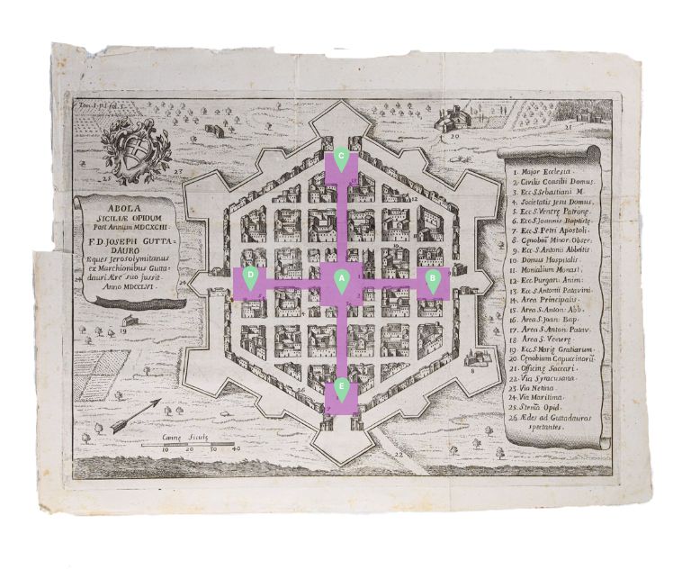
- Piazza Umberto I (Area Principalis o Piazza Maggiore)
- Piazza Regina Elena (Area S. Antonii Abbatis)
- Piazza Vittorio Veneto (Area S. Antonii Patavini)
- Piazza Teatro (Area S. Venerae Patronae)
- Piazza Trieste (Area S. Joannis Baptistae)
Four additional squares marked the endpoints of the “cross,” and the city gates were situated along the walls. Thus, in the feudal era, a highly democratic urban plan was realized, allowing all citizens, regardless of their social status, to have equal access to streets of the same width and dignity. At the same time, seismic prevention measures were implemented, as the wide streets served as escape routes, connecting the symmetrical “areas” at equidistant points. Regarding buildings, only one additional floor was allowed for the purpose of earthquake resistance.